Path of Potential Cyclone Behind Hurricane Erin Suddenly Shifts
 The expected path of a disturbance in the Atlantic Ocean behind Hurricane Erin—with the potential to develop into a cyclone—has shifted since Tuesday, according to data from the National Hurricane Center (NHC).
Why It Matters
Erin is the fifth named storm and first hurricane of the 2025 Atlantic season. Forecasters at the agency have warned that the system could bring life-threatening surf and rip currents to the U.S. East Coast.
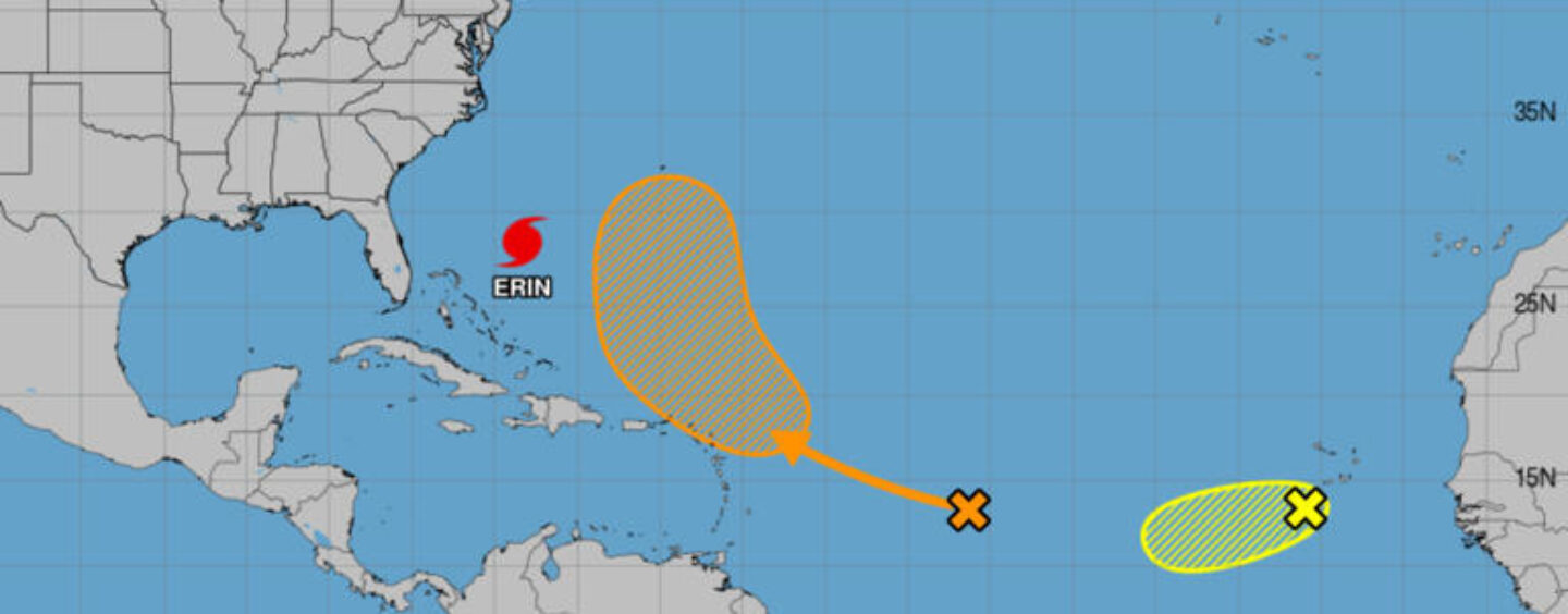
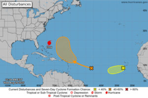
Meteorologists at the NHC are also tracking two disturbances with a chance of cyclone formation.
What To Know
As of 1:38 p.m. Eastern time on Tuesday, NHC graphics suggested the disturbance was expected to track northwest over Puerto Rico and the Dominican Republic.
By early Wednesday, updated NHC maps instead showed it curving northward before reaching Puerto Rico.
“A tropical wave located over the central tropical Atlantic continues to produce a broad area of disorganized showers and thunderstorms,” the NHC said.
“Environmental conditions appear conducive for gradual development of this system, and a tropical depression could form late this week or over the weekend while it moves near or to the north of the northern Leeward Islands.”
According to the agency, the disturbance had a 10 percent chance of cyclone formation through 48 hours, and a “medium” 60 percent chance through seven days.
The NHC also continued to track a second disturbance in the Atlantic on Monday, which the agency gave a “low” 30 percent chance of development through both 48 hours and seven days as of early Wednesday.
“Recent satellite-derived wind data indicate that a concentrated area of showers and thunderstorms located just southwest of the Cabo Verde Islands lacks a closed surface circulation,” the agency said. “Environmental conditions appear marginally favorable for additional development over the next day or so while the system moves westward at around 15 mph.”
“By the end of the week, environmental conditions are expected to become unfavorable for further development,” it added.
What People Are Saying
Meteorologist James Spann wrote on X on Tuesday: “NHC gives this feature a 60 percent chance of becoming a depression or tropical storm; all 51 members of the reliable European global model show it turning north into the open Atlantic well east of the U.S.
“No tropical storms or hurricanes are expected across the Gulf at least for the next 7-10 days.”
Meteorologist Ed Piotrowski wrote on X on Tuesday: “Odds favor the next tropical disturbance becoming a tropical depression over the next week. The GFS and Euro ensembles are encouraging and indicate this system could follow Erin and stay off the coast next week. Too soon to be confident of that, but I like the trends.”
Written by Joe Edwards

No Comments so far
Jump into a conversationNo Comments Yet!
You can be the one to start a conversation.Only registered users can comment.